

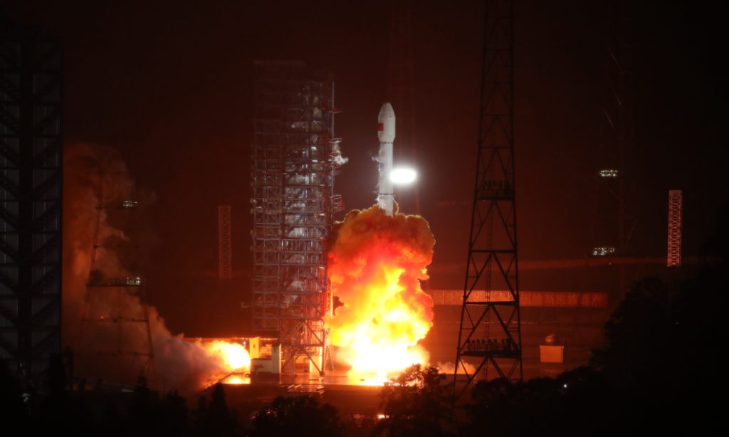
China successfully sent the Land Exploration-4 01 satellite, the worlds first high-orbit synthetic aperture radar (SAR) satellite, into a preset orbit via a Long March-3B carrier rocket from the Xichang Satellite Launch Center in Southwest Chinas Sichuan Province at 1:26 am on Sunday.
The Global Times learned from the China National Space Administration (CNSA) which oversaw the organization of the launch and manages the satellite program, that the newly launched satellite is the worlds first high-orbit SAR satellite that has entered the engineering implementation phase. Able to provide all-weather and all-day observation of Chinas territory and surrounding areas, it will further improve the countrys space-based disaster monitoring system and is of great significance for comprehensively boosting the countrys disaster prevention, reduction, and relief capabilities.
The Land Exploration-4 01 satellite is a remote sensing research satellite listed in the countrys Medium and Long Term Development Plan for Civilian Space Infrastructure
(2015-2025.)The satellite operates in an inclined geosynchronous orbit and is equipped with a synthetic aperture radar payload with high resolution, wide coverage, multiple modes, and lightweight advantages, the CNSA revealed.
Compared with low-orbit satellites and optical satellites, the Land Exploration-4 01 satellite combines the advantages of a short revisit period and large imaging swath in high-orbit observation with the advantages of microwave observation that is not limited by weather conditions (all-weather) and not limited by lighting conditions (all-day), which can improve the accuracy and efficiency of identifying abnormal changes in weather and enhance the nations comprehensive disaster prevention and control capabilities, the CNSA said in a press release sent to the Global Times on Sunday.
With the satellite now in orbit, it will enrich Chinas key regional observation methods and provide all-weather and all-day observation of Chinas territory and surrounding areas, meeting the needs of disaster prevention and reduction, earthquake monitoring, land and resources surveying, as well as applications in industries such as the marine, water conservancy, meteorology, agriculture, environmental protection, and forestry industries, according to the press release.
State departments led by Chinas Ministry of Emergency Management, including the Ministry of Natural Resources, Ministry of Water Resources and China Meteorological Administration, are key users of the satellite and they will carry out construction of ground systems and operation systems according to their specific needs.
The satellite was developed by the China Academy of Spacecraft Technology (CAST.)This was the second disaster prevention-related satellite launched within a week by China, following the codenamed
2024上海龙凤
Environmental Surveyor 2F, launched by a Long March 2C rocket from the Taiyuan Satellite Launch Center in North Chinas Shanxi Province on Wednesday.
Also developed by CAST in Beijing, the satellite is tasked with using its synthetic aperture radar to obtain images and data to support disaster prevention and mitigation, ecological monitoring and emergency response efforts. Its users are the Ministry of Emergency Management and the Ministry of Ecology and Environment.
On Sunday, space industry observers hailed the countrys innovative strength in the space domain, which they say has been increasingly creating value in civilian applications and shows that the countrys space development upholds the concept of "putting people first."
During the recent heavy rainfall that impacted the Beijing-Tianjin-Hebei region in North China as well as Northeast Chinas Heilongjiang and Jilin provinces, 16 satellites, including Gaofen-3 remote sensing satellites, were deployed to provide rapid imaging services to assist disaster monitoring, according to the state-owned aerospace giant China Aerospace Science and Technology Corporation (CASC) on Saturday.
The CASC told the Global Times on Sunday that these near real-time satellite images taken over the hardest-hit flood areas have provided scientific data services to support disaster relief work.
相关文章Chinas first homegrown ocean drillship completes trial voyage, set to make contributions to deep ocean exploration
With the completion of the first trial voyage of Chinas first domestically built drilling ship, the Mengxiang (Dream in English), the country officially became the third country in the world - following the US and Japan - to possess its own professional ocean drillship, which is dubbed as the aircraft carrier in marine science. With […]
Chinese American film, TV festivals set up platform for co-opThe 19th Chinese American Film Festival (CAFF) and the Chinese American Television Festival (CATF) kicked off on Thursday in Los Angeles, the US, contributing to a close cultural exchange between the worlds two largest film markets. In a video address at the opening ceremony, Yang Guorui, deputy director of Chinas National Radio and Television Administration, […]
China strongly condemns a violent attack as a vehicle crashes into the Chinese consulate in San Francisco
Following an incident in which a vehicle rammed into the Chinese Consulate in San Francisco on Monday afternoon local time, the Chinese Foreign Ministry, along with the Chinese consulate, voiced strong condemnations of this attack, and urged the US to swiftly conduct an inquiry and to take robust measures to ensure the safety of Chinese […]
China-ASEAN cooperation under BRI provides tangible benefits for region, gives impetus for future growth: Secretary-General of the ASEAN-China Center
Editors Note: On October 18, 2023, as the third Belt and Road Forum for International Cooperation (BRF) came to a conclusion, Chinese President Xi Jinping announced eight major steps China will take to support high-quality Belt and Road cooperation in a keynote speech. Benefiting over 150 countries, the Belt and Road Initiative (BRI) has become the most popular […]
还没有评论,来说两句吧...